
The depression will intensify into a deep depression --- the third and fourth stage of any cyclone formation --- by this evening. It will intensify into a cyclonic storm by June 2, the Cyclone Warning Division of the IMD said.

The weather system over the South Andaman Sea and the adjoining southeast Bay of Bengal is very likely to move north-westwards and strengthen into a depression by Saturday, the Met Department said.

The orange alert implies that authorities should be ready to handle situations arising out of severe weather.

"We are expecting that the temperature will be higher than normal in the entire northwest India and the adjoining central India, starting with Gujarat, Rajasthan and up to east Madhya Pradesh and Chhattisgarh," he said at a virtual event on 'Building Climate Resilience for the Most Heat Vulnerable'.

Besides strengthening the IMD's infrastructure, Mohapatra said his priority will be to improve the dissemination of weather-related information -- from nowcasts to weather forecasts -- focus on sector-related forecast and give impact-based prediction in all areas.

The cyclonic storm is likely to move nearly westwards and cross north Andhra Pradesh-south Odisha coasts between Kalingapatnam and Gopalpur around Sunday evening, the Cyclone Warning Division of the IMD said.

According to IMD, the cyclonic storm weakened into a 'deep depression' at 11:30 pm on Friday over Southeast Pakistan.

Rainfall in August is predicted to be below normal (less than 94 per cent of LPA), but the situation is expected to improve comparatively in September, the IMD said.

'There was a slight change of direction towards north-eastwards which meant the impact of the cyclone on Mumbai was less severe than originally expected,' the IMD said in a statement.

Above-normal heatwave days are predicted in most parts of central, east and northwest India during this period.

Several parts of north and west India reeled under scorching heat wave with the temperature touching 50 degree Celsius in Rajasthan's Churu district on Tuesday, even as the meteorological department predicted very heavy rainfall in Assam and Meghalaya till May 28.

Aizawl has been cut off from the rest of the country due to a landslide on National Highway 6 at Hunthar.

The trough over the Bay of Bengal, which has caused the torrential downpour in the state, will weaken in next 48 hours.

Traffic was thrown out of gear; visibility dipped, leading to delays in flights.

The southwest monsoon might finally start withdrawing from parts of North-West India over the next three days, signaling the end of its four-month journey over the country that started in June, the India Meteorological Department (IMD) said. However, though the retreat might begin from next week, the rains might not descend quickly, as the met department predicted fresh spells of rains in Vidarbha, Chhattisgarh and east MP on September 21-22 and over Odisha, Coastal areas north Andhra Pradesh and Gangetic West Bengal on September 19-21. "Due to anti-cyclonic flows over northwest India at lower tropospheric levels, dry weather is very likely over west Rajasthan, Punjab, Haryana, Chandigarh and Delhi during the next five days. "Hence conditions are becoming favourable for the withdrawal of Southwest Monsoon from parts of northwest India during next three days," the IMD said.
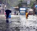
Some low-lying places like Hindmata, and areas in Dadar and Sion, including the Gandhi Market and road number 24 in Sion, were inundated, forcing pedestrians to wade through the water and making it difficult for motorists to commute.

Monsoon normally starts withdrawing beginning September 1 from west Rajasthan.

Kerala has been receiving rainfall since Saturday and 10 out of the 14 weather monitoring stations in the state have received more than 2.5 mm rains.

INSAT-3D, developed by the Indian Space Research Organisation and its Space Applications Centre, is designed to provide meteorological observation and monitoring of land/ocean surfaces.

Some India states are likely to record a significantly higher number of heatwave days, according to the national weather body.

The IMD had initially predicted that Cyclone Nivar was likely to intensify into a 'severe cyclonic storm' but has now estimated that it will intensify further.

The Delhi airport, the country's busiest airport, on Friday early morning witnessed the collapse of a roof at Terminal 1 amid heavy rains that killed one person, prompting the government to order a detailed probe and an inspection of the structural strength of all airports.

The rainfall in July was minus seven per cent which comes to around 93 per cent of the Long Period Average, IMD Director General Mrutyunjay Mohapatra said.

By now, monsoon should have reached the central India, including parts of Madhya Pradesh, Rajasthan, eastern Uttar Pradesh and Gujarat, but it is yet to reach Maharashtra.

June 1 is the official onset date of monsoon in India when it hits Kerala.

Monsoon in August was almost 24 per cent below normal, which was the sixth driest August since 1901. It came on the back of a 7-per cent monsoon shortfall in July.

The country can expect normal rainfall during the southwest monsoon season as a positive Indian Ocean Dipole (IOD) and a lower snow cover over the northern hemisphere are likely to counter the evolving El Nino conditions, the India meteorological department (IMD) said on Tuesday.

As the month ended with 33 per cent deficiency, which translates to around 67 per cent of the Long Period Average, several parts of the country have been witnessing drought-like situation.

So far, over 30 people have died across Northeastern states due to heavy rainfalls, floods and landslides, according to media reports.

Monsoon normally hits Kerala on June 1 but this year, Met department had predicted that it will hit the state on June 5.


Cyclone 'Biparjoy' has an extensive damaging potential and it is likely to impact Kutch, Devbhoomi Dwarka and Jamnagar districts of Gujarat the most, the India meteorological department said on Tuesday.

Data from department of agriculture showed that kharif crops had been sown in around 31.56 million hectares till Friday, which was 104.25 per cent more than the same period last year. Acreage of almost all crops was higher than last year.

Several global models are predicting El Nio to appear around the second half of the year, which are the crucial rain-bearing months.
The news will augur well for the country as large parts have been witnessing agriculture distress and water levels in reservoirs in west and south India have dipped to low levels.

Installed at a cost of Rs 450 crore in Pune and Noida, the two supercomputers are set to fundamentally alter the weather forecasting scenario in India by enabling the IMD to forecast severe weather conditions up to the sub-district or block level.

This could have huge implications for agriculture, food prices, supply and overall economic growth of the country

Next week could see some respite from the heat.

A likely western disturbance over north India during the weekend might cause heavy to very heavy showers in a few places, including New Delhi.

The cyclone is likely to bring heavy rainfall in its wake in parts of Maharashtra, Gujarat and Goa. The light showers/drizzle in parts of Mumbai city, its suburbs and neighbouring districts of Thane and Palghar on Monday morning brought some respite to people from the sweltering heat and humidity.